

OLD BELFAST QUAYS.
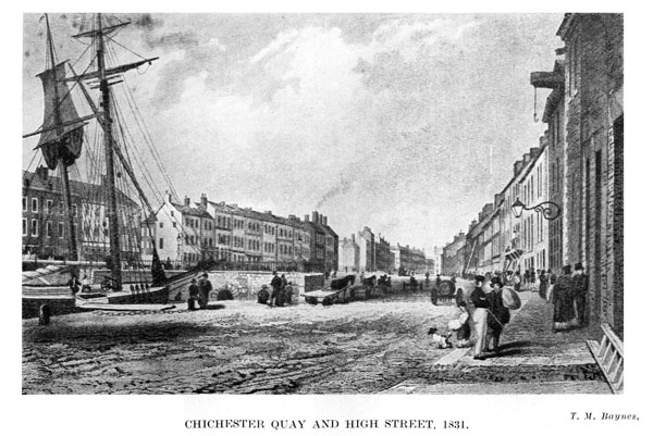
In Ireland Illustrated, printed in London, 1831, there appears an engraving by T. M. Baynes, entitled "High Street, Belfast", which is described in the text by G. N. Wright, M.A., Professor of Antiquities in the Royal Hibernian Academy, etc., as follows :--
"This avenue is very characteristic of the busy town of Belfast. It stretches from the old basin to the end of Donegall Place, and betrays the level and the low surface on which the town is built. The safe asylum, at last attained of the toiling mariner, occupies the left; the less dignified means of transferring burdens to which terra firma restricts her children, mark the centre; and the broad, great vista extending into the distance may be fairly expected to excite the idea of a town possessing the magnitude, character, and commercial enterprise, so honourably earned, and so universally conceded to Belfast."
The above description is inaccurate and imperfect. The sailing vessel is moored at the Chichester Kay which dates back to 1769; and, so far as I have been able to trace, Baynes' engraving is its only pictorial representation.
"On Monday when the agreeable News arrived of Lady Donegall being safely delivered of a Son and Heir, Mr. Thomas Greg laid the Corner Foundation Stone at the Termination next the Sea, of the new Kay which he is building on the North side of the Dock of Belfast. This Kay is 320 feet in Length, and which, when finished will give Room for the Accommodation of a much greater Number of Ships, and in deeper Water than heretofore; and Mr. Greg, in Commemoration of the Birth of Lord Chichester, hath called the said Kay, Chichester Kay."
Belfast News-Letter, Friday, 25th August, 1769.
The Lord Chichester, above referred to, was George Augustus, afterwards second Marquis of Donegall, who was born 13th August, 1769 :--
"This morning arrived the account of the Right Hon. the Countess of Donegall's being safely delivered of a Son and Heir, at the Earl of Donegall's House in St. James's Square, London. An event of such importance to his Lordship's Family and to the welfare and prosperity of the town occasioned universal joy. At Noon, the Sovereign, Burgesses, and principal Inhabitants assembled at the Castle, where they were received by Charles Henry Talbot, Esq., and, after having paid their compliments of Congratulation, walked in procession to the ground mark'd out for an elegant Exchange and Assembly-Room to be built at his Lordship's sole expence, when Mr Talbot laid the first Stone of that useful Edifice in honour of the Day."
"The Healths of the Earl and Countess of Donegall, Lord Chichester and Lady Emily Chichester were then drank and all other public demonstrations of Joy. At night, the Sovereign, Mr Talbot, and the principal Gentlemen met at the Market-house, on the happy occasion. Drink was given to the populace, great bonfires were made, and the Castle and Town were splendidly illuminated."
Belfast News-Letter, Tuesday, 22nd August, 1769.
Although the Foundation Stone was laid in August, 1769, and the name Chichester then chosen, the construction of the Kay had been in progress for some time previously. A Donegall lease, dated 20th July, 1767, had been granted to Thomas Greg, merchant, of
"all that piece or parcel of ground, situate, lying, and being at the E end of the Old Quay on the N of the High Street... bounded towards the S by the River Millrace; towards the E by the Strand or seashore; towards the N by the Dock leading to the Salt Pans in the possession of James Patrick merchant; and adjoining the other ground there in the possession of and intended to be... to R Thompson merchant; and towards the W part by ground and buildings then in the tenure of said Thomas Greg and which said piece or parcel of ground thereby demised contains in width towards the S 350 feet... and in depth towards the E along the seashore 206 feet or thereabouts."
and also
"all the Wharf or Quay called or known by the name of Hanover Quay... and extending from the Sluice Bridge to the Long Bridge in full and free liberty... to acknowledge, demand, and receive... any sum or sums of money... on the 1st day of May which will be in the year of our Lord, 1791, shall be... layed or put upon the said Wharf or Quay called the Hanover Quay."
and also
"the free use and enjoyment of all that Dock, Canal, Cut, or Watercourse situate and being on the N side of the said demised premises called the Salt Pan Dock, in common with the owners or occupiers for the time being of the premises adjoining thereto and then in the tenure or occupation of the said James Patrick and R Thompson respectively for the passing and repassing of barges and other vessels to and from the ground by the said indenture demised and the said other premises then in the occupation of the said James Patrick and R Thompson respectively as aforesaid."
It will be seen from the above lease of 1767 that Thomas Greg was in possession of Hanover Quay on the south side which extended "from the Sluice Bridge to the Long Bridge". The Sluice Bridge was that spanning the Farset and connecting Skipper Street with Schoolhouse alias Church Lane. That Bridge was not in existence in 1831, the date of the engraving, as the Farset and what appears in the 1685 map as "The Dock" had been covered over to a point east of Princes Street. Hanover Quay was originally that portion of the Donegall Quay from Queen's Bridge to Queen's Square and the side of Queen's Square was called "George's Quay", after Black George McCartney, whose son Isaac developed all the slob Iande of the Corporation Church, alias St. Georges. The name Hanover Quay was changed to Custom-house Quay, and the name Hanover Quay substituted for George's Quay, until the present name of Queen's Square included both Chichester Quay on the north and Hanover Quay on the south.
Some indication of these changes may be seen from various parcels of leases, as they appear in a "Rental and Particulars", prepared for a Sale by Public Auction on Friday, 22nd July, 1859. The words, as used therein, "now called", indicate the name by which the particular Quay was known in 1859.
In a lease, bearing date 3rd October, 1770 :-- "a piece of ground, situate in Donegall Quay, then called George's Quay."
In a lease bearing date 6th August, 1774, George Macartney granted to George M. Portis, Collector of His Majesty's Revenue in the port and district of Belfast, "all that the Custom House of Belfast... bounded on the north by George's Quay (now called Queen's Square)... on the east by Hanover Quay (now called Donegall Quay)... "
In a lease bearing date 15th February, 1803 :-- "that tenement situate... in George's Quay (now called Queen's Square) ".
In a lease bearing date 10th December, 1822 :-- "that enclosed yard or parcel of ground on Custom-house Quay (now called Donegall Quay) ".
In a lease bearing date 20th May, 1826 :-- "all that piece... of ground situate... on George's Quay (now called Queen's Square) and extending backwards to Stable Lane (now called Prince's Court) ".
In a lease bearing date 5th April, 1838 :-- "all that piece of ground... situate... in Hanover Quay (now called Queen's Square) ".
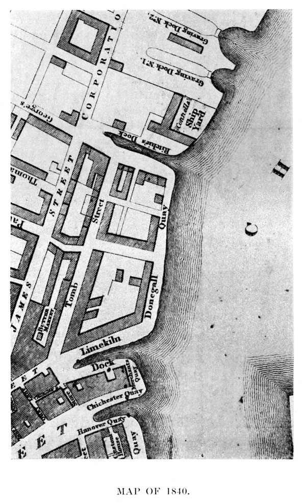
It will be seen from the above Map that the south side of the present Queen's Square was Hanover Quay and the north side Chichester Quay; that the present Albert Square was Limekiln Dock; and that the present Corporation Square was Ritchie's Dock. Donegall Quay then only included from the present Albert Square to Corporation Square: and the east side of the present Custom House was Merchants Quay.
We see from the 1715 Map that "Marchant kye" extended along the north side of "The Dock" as far west as "Skipars lean", while the south side of "The Dock" was "Georges kye", so-called after George Macartney niger, father of Isaac to whom the kye belonged. All these names were subsequently transferred -- Georges kye becoming Hannover kye ; Hannover kye becoming Custom-house key; and Marchant kye becoming Chichester Kye.
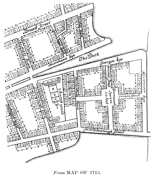
Maclanachan was clearly in error when he showed Brunswick Square at the junction of Princes Street and Marlborough Street. The name seems to have been applied to the whole of Isaac McCartney's property in the neighbourhood of Hannover Key alias Donegall Quay.
The earliest mention of Brunswick Square is in a lease, bearing date 22nd February, 1715, from Isaac McCartney to the Hon. John Itchingham Chichester of
"all that plott or parcel of ground as set in Brunswick Square in the town of Belfast, adjoining to the yard intended for the Custom House, containing in front to Hanover Key 40 feet and extending backwards to the backside of the house built by James Wilson gentleman 80 feet."
An Assignment, dated 1st May, 1722, and made between Neile McNeile, Apothecary, administrator of the Goods of Dorothea Dorinda Smith, late of Belfast, spinster, deceased, and also Administrator de bonis non of the Hon. John Itchingham Chichester, Esq., deceased to Isaac McCartney --
"Recites that Isaac McCartney by lease of 22 February, 1715 did demise unto the said John Itchingham Chichester for the term of 69 years... at the yearly rent of £5 all that tenement... in Brunswick Square and joining to the wall of the yard intended for the Custom House in front to Hanover Quay... upon which plot... the said John Itchingham Chichester built a large dwelling house and office houses"
"Recites that the said John Itchingham Chichester assigned the said premises to... Isaac McCartney for securing the payment of £300 and interest
"Recited that the said John Itchingham Chichester by his Last Will and Testament devised said premises to said Dorothea Dorinda Smith and appointed her sole Executrix who died since intestate and administration of her goods and chattels and also administration de bonis non of the said J. I. Chichester were granted all that square plott or parcel of strand ground lying on the N side of the Highway leading to the Bridge and bounden on W side to the strand ground belonging to the said R Leathes and Lewis Thompson; and on the N with the Town Dock or River that runneth through the town of Belfast: on the E with the Lagan; and on S with the Highway aforesaid.
The name "Brunswick Square" again appears in a later deed, dated 19th March, 1838 :--
"an annuity or yearly rent charge of £22 sterling to be issuing out of all that one Dwelling-house with a Brew-house, Malt-house, and other office-houses belonging thereto, situate in Brunswick Square on or near Hanover Key."
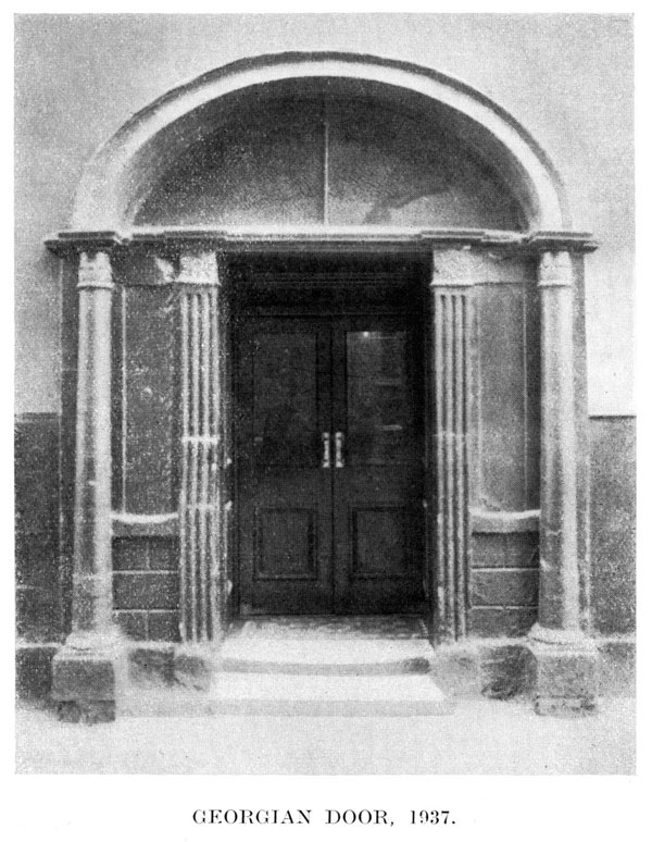
The above Georgian door, at present in Marlborough Street, is a mute witness of a byegone past. It recalls names such as Francis Turnly of Newtownards, who, in 1787, leased the ground on which it is situated, to Simon Vokes of Belfast, Esq.; and of his son, John Turnly, of Rockport, Co. Down, who, in 1832, leased the same ground to William Suffern of Belfast, merchant, the parcels of which are :--
"all... that piece... of ground, situate on the E side of Princes Street... containing in width at the front 80 feet and extending backwards along the S side of Marlborough Street 50 feet."
There is nothing to indicate who is responsible for the construction of that doorway but the intrinsic beauty of its outline displays a taste that is worthy of emulation, and a dignity that is in consonance with its early associations.