

OLD BRIDGES OF BELFAST.
THE GREAT BRIDGE.
The earliest bridge, of which there is any record as to its building, was that spanning the "Ryver of Owynvarra", which crossed "the hiway to lisburn," so called by Maclanachan, the first cartographer to name it, as unfortunately Phillips does not name any of the streets or roads in his 1685 map. It was built in 1642 by Edward, Viscount Chichester of Carrickfergus, brother to the Lord Deputy and father of the 1st Earl of Donegall, as appears in the Corporate Records :--
"24 die Junii, 1642. It is agreed that the worke att the Bridge shall be finished att the charge of the Lo: Chichester whoe hath begun itt, the wch his Lop's Officers have undertaken to do."
Consisting of three arches, it was called The Great Bridge of Belfast, as may be seen in the parcels of a Donegall lease, to R Douglass, brickmaker, bearing date 17th June, 1689 :--
"all that plott or parcel of ground situate... in the fields of Belfast, on the S.W. part of said Town, between the Pound, where was formerly the great Sluce of the Mill Dam, and the Great Bridge leading to Malone, on the W side of the Highway between the said Pound and the Bridge, bounded between the said Highway all along the E and S and the River which falleth from the Pound on the W."
It must be remembered that the Long Bridge, with its twenty-one arches, was not built until forty years after the erection of the Great Bridge, when the name"Great" was gradually dropped and "Brickill" substituted, thus indicating that the Bridge was situated at the Brick Pits or "Brick Kiln Land". The name was again changed to "Salt Water Bridge," as it appcars on Williamson's 1791 Map. In 1717, seventy five years after its erection, the Grand Jury made an assessment for building buttresses "to support the Salt Water Bridge and for other repairs about the said Bridge."
The Great Bridge is closely identified with the first water supply of Belfast, as being the place to which the supply was conveyed
"in pumps or wooden pipes from ye Upper or Tuck Mill Dame to ye great bridge of ye said Towne (contayneing about 200 pearch in Lenth) a place most convenient to supply ye whole Towne with water by a Comon Conduit."
The originators of the scheme were Black George McCartney of Blacket (not, as Benn and Young both wrongly assert, the ancestor of Earl Macartney) and Capt. Robt. Leathes who, as Sovereign, presented "ye rod of Authority" to King William III, in June, 1690. The cost of the undertaking was estimated at "neere two hundred and fifty pound ster." but the work was completed for the lesser sum of £175, towards which Letitia, Countess Dowager of Donegall
"voluntary to incourage soe good a worke has paid and promised to pay ye sume of forty punds ster."
An appeal was made for the remaining £135 and it was anticipated that the inhabitants would
"give their free will offeringe to defray ye said charge, as verely believing every p'son that has a regard to his owne health will be moste ready and willing to further ye said worke."
That anticipation, however, was not realised and an assessment was made four years later, 11th May, 1682 :--
"That ye Soveraigne for ye time being issue out warrants from time to time to ye Severall Sessers that were and are now chosen since ye 8th of August, 1678, requireing them or any three or more of them equally to applott and Sesse on ye Inhabitants of Bellfast accordinge to their severall Estates and abillityes the said sume of one hundred thirty five pounds ster. and that ye same may be forthwith lieved (levied) and paid to ye said George McCartney to reimbursse himselfe ye charges of ye said worke."
In the Corporate Record of 1678 there is no mention of a water house, but it is recorded on 16th July, 1682 :--
"perfeited ye saide worke in wooden pipes bound with Iron contayneinge in lenth 200 Irish pearch with water house and three conduits (runing)."
The mention of "water house" points, as I think, unmistakeably to the fact that in 1678 the water was taken "in wooden pipes bound with Iron" from the Tuck Mill Dame to the "water house", from which there were "three conduits (runing)".
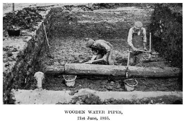
Through the kindness of the Curator of the Municipal Muscum, Mr. Arthur Deane, M.R.I.A., I am enabled to reproduce in situ one of the seventeenth century wooden pipes, recently unearthed, while preparing for the newly-constructed Boyne Bridge which spans the railroad of the Great Northern Railway.
The reason for initiating the 1678 system of water supply is recorded as follows :--
"Wheras the Towne of Belfast, for many yeares last past, has been very defective of good clean and wholesome water, to ye prejudiceing ye health of the Inhabitants."
In the early seventies of the last century, Mr. Thomas Gaffikin delivered a lecture on "Belfast Fifty Years Ago", in which he says :
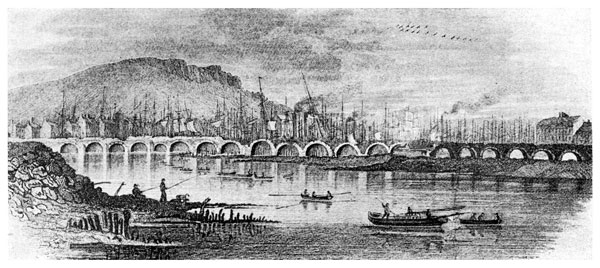
"The old Long Bridge was composed of twenty-one arches; it was very narrow; and had no footways. The breakwater or pier between some of the arches was carried up to the retaining wall and formed little angular recesses, which people sometimes had to step into when two conveyallces were passing. Two of such niches are still to be seen on the old Salt Water Bridge, Sandy Row."
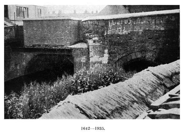
That statement of Mr. Gaffikin is corroborative proof that the original bridge had three arches, as each angular recess or niche was above a pier separating the arches and there was no occasion for a recess at either end. One of those three arches had evidently disappeared during the sixty years that had ended in 1935 when the reconstruction of the Boyne Bridge was begun.
Fortunately, through the thoughtful foresight of Mr. A.H. George, one of the staff of the Municipal Museum, the outline of the original bridge has been preserved for all time by a photographic reproduction which shows not only the graceful curvature of its two remaining arches, but the angular recess on the roadway, used by pedestrians to avoid the vehicular traffic.
The photograph was taken on 21st June, 1935, before the old wooden pipe was removed from its original position, where it had lain for two and a half centuries. The pipe is placed from north to south and the tapering spigot is at the north end. The wooden pipe itself measures 14 feet, having a bore of 4 1/2 inches while the thickness of the body is 2 inches. The men are engaged in sinking for the foundation of the pier which supports the Boyne Bridge on the south side of the main railroad to Dublin. From the position of the pipe it would seem that the line of wooden piping ran beneath the Great Northern Railroad, but whether the wooden pipes were removed at the time of forming the railroad is not known.
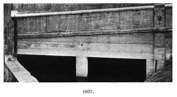
During the rebuilding of the Boyne Bridge, the Great Bridge of Belfast, alias Brickill Bridge, alias Salt Water Bridge, was incorporated in the reconstruction. Two of the original arches, built of local blue whinstone and covering a stretch of 46 feet from north to south, were then, according to Mr. Henry Martin, Senior Director of H. & J. Martin, Ltd., still good and sound. But to-day one looks in vain for that sole survival of the seventeenth century Belfast. Built in 1642, during the troublesome times of the Rebellion of that period, it had more historic associations than any other part of the city. Its arches had resounded to the endless tramp of armies, marching to and from the town; the structure had endured the weight of the Duke of Schomberg's heavy artillery on his march southward to the Boyne; it was the route of William III and his attendant officers on 19th June, 1690, after landing at Carrickfergus five days earlier from the Mary Yacht, under the Command of Captain Grenville Collins, and resting in Belfast Castle during the interval; it was the direct road to Lisburn and the South of Ireland, to and from which the old Coach and Six trundled along with the occasional blast of the Coachman's Horn; and underneath its curved arches flowed an ample supply of water from The Squire's Hill, after the Clowney Water had joined the overflow from the Tuck Mill Dam to form the "Ryver of Owynvarra" which, for a lengthened period of time, was the driving power of Joy's Paper Mill of a vanished past. With all such venerable and historic associations the Great Bridge of Belfast has been, so to speak, buried alive in a concrete coffin, without a nameplate to indicate its former existence, or even its place of interment.
That the Salt Water Bridge owed its name to the river being tidal at that point is borne out by the Ordnance Survey Map, 1932 edition, which shows further up the river, at the goods shed of the Great Northern Railway :-- "Weir: Highest point to which ordinary tides flow."
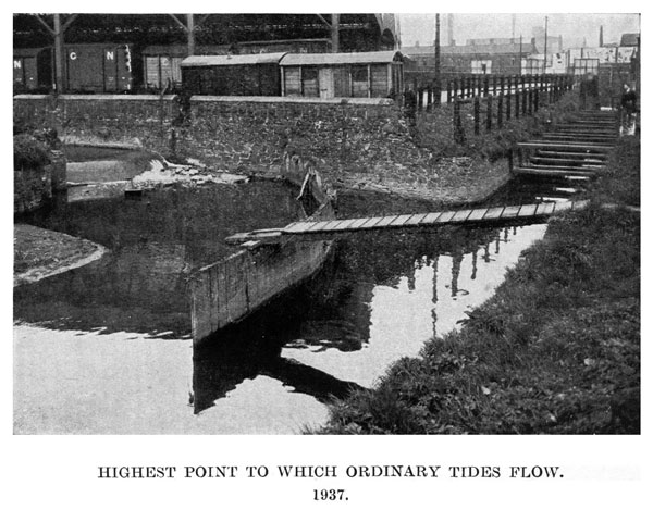
The straight. course of water in the above illustration is an overflow from the Farset at the Pound. Joined by the Clowney Water from the west the two united waters flow underneath Murray's Tobacco Factory and, turning abruptly towards the east, enter the Great Bridge of Belfast, now buried beneath the Boyne Bridge. Thence to Croac Bridge is the Blackstaff alias "the Ryver of Owynvarra " discharging its waters into the Lagan on its seaward course. The Clowney Water rises on The Squire's Hill (see Illustration, p.9) and is called the Forth River on its upward reach, passes underneath the Ballysillan Road and proceeds via Springfield underneath a bridge on the Falls Road and thence to the Great Bridge.
THE LONG BRIDGE.
The Long Bridge of Belfast, the foundation of which was laid in 1682, had a somewhat chequered career during its existence of a century and a half. Shortly after it was completed the heavy artillery of the Duke of Schomberg, on his march from Bangor to Belfast, considerably weakened the structure and in 1692, seven of its arches collapsed. A few years later a vessel was blown against it in a storm and the Burgesses, at an Assembly held on 22nd October, 1696.
"Ordered, upon presentment of ye Grand Jury for preventing ye doing damage on ye new Bridge, that hereafter no vessell ly at anchor to ye southward of ye Dock and that such as are on ye north side of ye Dock be well moored on pain of forty shillings at tide fine for ye preservation of ye Bridge for ye future."
As the "Dock" was situated at the present Queen's Square, it will be seen that vessels were prohibited from lying at anchor towards the present Queen's Bridge, while those lying towards the Lough were to be "well moored", under penalty of forty shillings for each tide."
The Compleat Irish Traveller, published in 1788, gives the following account of the Long Bridge :--
"We proceeded to Belfast, in the county of Antrim, where there is a bridge, under which the river Lagan empties itself into Carrickfergus Bay, and it is one of the most stately in the kingdom, consisting of twenty-one arches, all turned with hewn freestone raised in the hill of Scraba, of which eighteen are on the county of Down side and three in the county of Antrim, the channel dividing the two counties running through the third arch. The whole bridge, and the dead work at each end extended over the marshy grounds, is 2,562 feet long, of which the twenty-one arches take up 840 feet, and the dead work 1,722 feet. The breadth of the arched part is twenty-two feet, and of the rest nineteen. It was built at the joint expense of the two counties and cost about 8,000l. (some say 12,000l.) The foundation of it was laid about the year 1682, and it was not completely finished until the Revolution."
"From thence we proceeded eight miles down the river to Carrickfergus, its sea-port, which is situated in a bay of its name... The entrance into it is bold, being about five miles wide, and having a depth of water from twenty to twelve fathom, which grows gradually shallower till you advance opposite to the town of Carrickfergus, when it is from five to eight fathom deep in the middle of the road. It grows narrower by degrees, for several leagues from the mouth to the bridge of Belfast, where it is not above three quarters of a mile broad, if so much, and there at full sea, it is not above eight or nine feet in depth, and at low water not above a foot, except in freshes, when something deeper."
Vol. II, p. 239.
The following incident, recorded in the Preface to Vol. I of Sermons on Various Subjects by John Abernethy, M.A. (1748) verifies the imperfect construction of the Bridge :--
"It may not be disagreeable to the reader to mention a very remarkable interposition of Providence in preserving his life, when on his way to Scotland" [about 1692]. "At Belfast he was diverting himself with a servant who attended him, upon the great bridge, by which that town is joined to the county of Down; they stood upon the bridge for a considerable time; but Mr. Abernethy, happening to cast his eye upon something at a distance which catched his fancy, they ran off on a sudden: &, the moment they removed, the arch, upon which they had been standing, fell down: so they very narrowly escaped being crushed to pieces."
Bradshaw in his Directory of Belfast for 1819, states the following:
"A report upon oath, having been made, November 1817, by Mr. Larkin, as surveyor to the general Post Office, of the total insufficiency of this bridge, and the danger attending it -- the Editor of the Directory trusts, that the following two measurements of the River Lagan about the parts where a new bridge may probably be erected, will, in the present early stage of the subject, be an interesting document to the noblemen, gentry, and others interested in the connexion between the two great and flourishing counties of Down and Antrim."
"The River Lagan, in a direct line, in continuation of May Street, passing the south side of the markets, measures, from bank to bank, at high water, six hundred and twenty six feet. This line would enter the County of Down near the road from Saintfield."
"Do, in continuation of Chichester-street, passing the north side of the markets, measures thirteen hundred and fourteen feet. This line would enter the County of Down near the east end of the present bridge, running diagonally across the river."
Benn in his anonymous History of the Town of Belfast (1823), says :--
"The number of arches is twenty-one. Several of these have been closed, and the others are extremely unequal in size... from whatever cause it has arisen also, great doubts have long been entertained and expressed as to its stability. In the year 1744, Mr. Harris speaks of the injuries which it had sustained from the winter floods, and the danger which attended several large chasms in the arches. By another surveyor in 1817 a similar account was made of its dilapidated condition, and a very general belief of its insecurity was occasioned. From a still later examination, however, it was reported that these statements were incorrect, and that more danger is to be apprehended from the extreme narrowness of this bridge (which is only twenty-two feet wide) than from any other cause."
From these various sources we obtain the following information about the Long Bridge, described by an English traveller as "one of the most stately in the kingdom", a description amply borne out by the water colour drawing of Andrew Nicholl, R.H.A. (see Frontispiece). The construction of its twenty-one arches was started in 1682, consisting of County Down freestone from Scrabo Hill, near Newtownards. Three of its arches were in County Antrim and eighteen in County Down, the channel running through the third arch dividing the two counties. The cost of construction, about £8,000, was contributed by the two counties. The arches were 840 feet long and 22 feet wide, while the dead work at both ends extended over marshy ground for a distance of 1,722 feet and 19 feet wide, thus making the entire length 2,562 feet, or close upon half a mile.
Seven of its arches fell within ten years of their erection; the structure was seriously damaged by the winter floods of 1744; and in 1817, a Surveyor to the Post Office condemned it as dangerous and "totally insufficient". Notwithstanding its imperfections, the Long Bridge was not removed until the fourth decade of the nineteenth century, when it was replaced by Queen's Bridge, built by Francis Ritchie & Son, in 1841-1842, under the personal supervision of Dr. William Barry Ritchie, and opened for traffic in January, 1843.
THE BUILDERS OF QUEEN'S BRIDGE
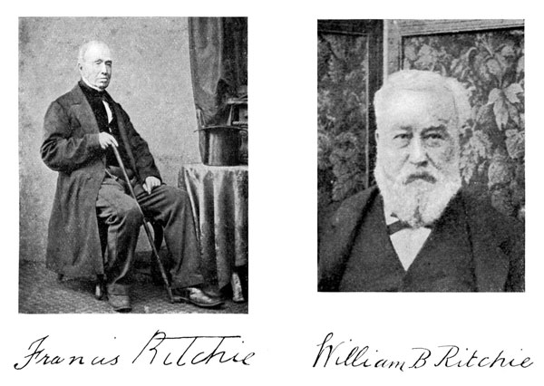
DEATH OF W. B. RITCHIE, M.D., J.P.
"Long before the death of his father, the well-known Francis Ritchie, which occurred in February, 1864, the gentleman whose sudden demise has now taken place was well known to the residents, not only of Belfast, but of a large portion of the North of Ireland. He had been closely associated with his father in the carrying out of a number of important contracts, one of the most noteworthy being the Queen's Bridge, which was built under his personal supervision. Shortly after the completion of that undertaking in 1844 (1842) the extensive chemical works were established in Ballymacarrett. The distillation of tar and the manufacture of felt occupied for a time almost the entire attention there... A kindly and philanthropic gentleman, a friend of social and scientific progress, an earnest though unobtrusive Liberal politician, an eminently good man of the class Belfast can least afford to lose, has passed away. The sorrow is general. Many tears will be shed over Dr. Ritchie's grave."
Northern Whig, 17th February, 1887.